Percorsi MTB
 English
 Italiano
 Deutsch
Descrizione del percorso
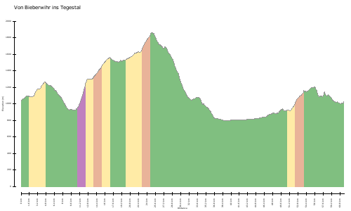
Abschlussfahrt 2012 Kurzbeschreibung: Strecke: ca. 60 km Höhenmeter: ca. 2435 m Fahrzeit: ca. 6:30 h (netto) Zeitbedarf: ca. 10:00 h (brutto) - Biberwier (Start) - Fernstein - Schweinsteinjoch - Obtarenz - Tarenz - Nassereith - Marienbergjoch - Biberwier (Ziel) Schöne Tour um den Fernpass auf dem Weg der alten Römer (Via). Kondition, Ausdauer und Technik sind gefragt. Die Tour verläuft überwiegend auf Schotterwegen, zwischendrin gibt es auch etwas Asphalt. Genial ist der wohl schönste Bergauf-Trail, der vollständig fahrbar ist. Der Schluss wird mit einigen schönen, technisch durchaus anspruchsvollen Singletrails belohnt. x-x-x-x-x-x-x-x-x-x-x-x-x-x-x-x-x-x-x-x-x-x-x-x-x-x-x-x-x-x Startpunkt der Tour ist der hintere Parkplatz am Ortsende von Biberwier. Dort kann man umsonst parken und direkt losfahren. Der Weg beginnt links vom Hotel und führt hinter diesem vorbei. Wir folgen des Beschilderung in Richtung Fernpass/Nassereith (Via) und rollen bergauf/bergab in Richtung Fernpass. Zwischendrin gibt es einen kleinen Trail als Abkürzung. Wer diesen nicht mag, folgt weiter dem Track. Vorbei am Weißensee und Fernsteinsee erreichen wir den Campingplatz Schloss Fernstein, an welchem wir rechts abbiegen und dem Fahrweg nach oben folgen. Am Schweinsteinjoch angekommen, biegen wir links auf besagten Trail ein, der uns weiter nach oben führt. Oben angekommen, genießen wir die fantastische Aussicht zum Wettersteingebirge, dem Marienberg und über das Tal des Fernpass. Danach führt uns der Weg auf dem schnellsten Weg hinunter nach Obtarenz und Tarenz, wo wir eine eine längere Pause empfehlen. Gestärkt folgen wir dem Römerweg (Via, am Wald entlang) in Richtung Nassereith. In Nassereith angekommen, halten wir uns rechts und folgen den Schildern zur Marienbergalm. Am Zielbanner der 1. Österreichischen Asphaltrodelbahn beginnt der Anstieg, welcher uns erst über Asphalt, dann über Schotter zur Marienbergalm führt. Weiter passieren wir das Marienbergjoch an welchem die Abfahrt entlang der Skipiste beginnt. Wer Abwechslung möchte, folgt der Beschilderung des Barbarasteig und betritt damit die Singetrials abseits der Fahrstrecke (Bitte auf Wanderer achten!). Alternativ dazu kann man natürlich auch dem Weg folgen oder über die Skipiste fahren. Zum Schluss sollte aber jeder noch einmal die Skipiste betreten, bevor wir wieder am Parklatz in Biberwier ankommen. Ich hoffe, Ihr hattet Spaß. CD
http://www.gps-tour.info/en/tracks/detail.110376.html
Graduation trip in 2012 Description: Distance: 60 km Altitude: approx. 2435 m Travel time: approx 6:30 (net) Duration: approx 10:00 (gross) - Lermoos (Start) - Fernstein - Schweinsteinjoch - Obtarenz - Tarenz - Wet Reith - Marienbergjoch - Lermoos (target) Beautiful tour around the Fern Pass on the way the ancient Romans (Via). Fitness, endurance and technique are required. The route runs mainly on gravel roads, in between there are also some asphalt. Genial is the most beautiful uphill trail that is fully mobile. The final will be rewarded with some beautiful, technically quite challenging single trails. xxxxxxxxxxxxxxxxxxxxx-xxxxxxxxx starting point of the tour is the rear parking lot on the outskirts of Lermoos. There you can park for free and start driving right away. The trail starts to the left from the hotel and takes you behind this over. We follow the signs to the Fern Pass / Wet Reith (Via) and roll uphill / downhill towards the Fern Pass. In between there is a small trail as a shortcut. Who does not like this, also follows the track. Passing the Weissensee and Fernstein we reach the campsite Fernstein castle, to which we turn right and follow the road to the top. On Schweinsteinjoch arrived, we turn left on said trail that takes us to the top. At the top, we enjoy the fantastic views to Wettersteingebirge, the Marienberg and the valley of the Fern Pass. Then the trail leads on the fastest way down to Obtarenz and Tarenz, where we recommend a longer break. Strengthened we follow the Roman road (Via, along the forest) towards Nassereith. In Nassereith arrived, we keep right and follow signs for Marienbergalm. At the finish banner of the 1st Austrian asphalt toboggan run, the increase, which leads us only on asphalt, then gravel to Marienbergalm begins. Next we pass the Marienbergjoch at which the exit along the ski slope starts. If you want to change, follows the signs of Barbara riser and thus enters the Sing Trials off the route (Please pay attention to hikers). Alternatively, you can of course also follow the path or take the ski slope. Finally, but everyone should again enter the ski slope before arriving back at the parking space in Lermoos. I hope you had fun. CD
http://www.gps-tour.info/en/tracks/detail.110376.html
Mappa/Altimetria
Immagini