MTB Trails
 English
 Italiano
 Deutsch
Trail Description
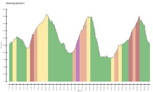
Meine Lieblingstour ;-) Den Weg hinter zur Tarrenton kann man sich sparen: Nix g'scheides zum Essen, besser Sandwich Pause beim höchsen Punkt (155) mit wunderbarem Blick. Danach ist es ein ziemlich geiler DH, für die geübten immer rechts halten. Unmitellbar vor Tarrenz, noch mal ein kleines Stückel hoch um die Trails der Salvesenklamm zu fahren (eigentlich verboten ;-) aber geil !)
http://www.gps-tour.info/en/tracks/detail.67796.html
My favorite tour;-) The path behind the Tarrenton you can save: & nbsp; Nix g'scheides to eat better sandwich break in & nbsp; höchsen & nbsp; point & nbsp; (155) & nbsp; offering a wonderful view. Then it's a pretty horny DH, for the & nbsp; practiced always keep to the right. Unmitellbar before Imst, still & nbsp; sometimes a little high Stückel & nbsp; ride around the trails of Salvesenklamm (actually, & nbsp; prohibited; -) & nbsp; but & nbsp; cool) & nbsp;!
http://www.gps-tour.info/en/tracks/detail.67796.html
Map/Elevation
Pictures