MTB Trails
 English
 Italiano
 Deutsch
Trail Description
Los gehts in Ostfildern. Dann runter ins Körschtal und am Möbel Rieger vorbei nach Zell. In Zell geht es über den Oberhof hinauf zum Jägerhaus. Von dort vorbei am Katzenbühl und hoch zum Kernenturm. Kurzen Abstecher zur Grabkapelle Württemberg mit einem wunderschönen Ausblick. Dann über den Esslinger Höhenweg zurück nach Esslingen. Nach kurzer Rast auf dem Hafenmarkt geht es an der Villa Merkel vorbei wieder hoch nach Berkheim.
http://www.gps-tour.info/en/tracks/detail.66640.html
Here we go in Ostfildern. Then down to the Körschtal and the furniture Rieger over to Zell. & Nbsp; cell in it is & nbsp; over the Oberhof up to. & Nbsp; Hunter House & nbsp; From there over & nbsp; Katzenbühl on and up to the tower core. Short detour to the grave chapel Württemberg & nbsp; having a beautiful & nbsp; view. Then on the Esslinger Trail back to Esslingen. After a short rest at the port market, it goes to the Villa Merkel passed back up to Berkheim. & Nbsp;
http://www.gps-tour.info/en/tracks/detail.66640.html
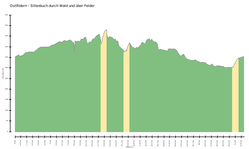
Map/Elevation
Pictures