MTB Trails
 English
 Italiano
 Deutsch
Trail Description
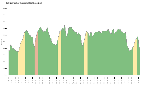
auf und ab im Dürrbachtal, ca 1200Hm, keine Strecke doppelt, holpert teilweise heftig ist aber auch mal asphalt dabei
http://www.gps-tour.info/en/tracks/detail.49414.html
up and down the Dürrbachtal, ca 1200Hm, no track twice, bumps sometimes violent but is sometimes asphalt thereby
http://www.gps-tour.info/en/tracks/detail.49414.html
Map/Elevation
Pictures