Percorsi MTB
 English
 Italiano
 Deutsch
Descrizione del percorso
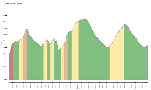
Der erste kurze Anstieg führt zur Schwarzenbergallee, welche man dann entlangfährt bis zum Beginn des Waldweges. Auf Waldwegen und Forststrassen geht es dann hinauf bis zum Excelberg (vorbei am Funkturm). Danach geht jetzt ziemlich rasant bergab, auf der Amundsenstrasse angekommen fährt man dort weiter bis zur Einfahrt zum Hanslteich. Von dort geht dann wieder ein Waldweg, bis man wieder zur Schwarzenbergallee kommt.
http://www.gps-tour.info/en/tracks/detail.18427.html
The first short climb leads to Black Mountain Parkway, which you then travels along until the beginning of the forest road. On forest roads and forest roads, it then goes up to the mountain Excel (past the radio tower). After that now goes pretty fast downhill, arrived at the Amundsen road you drive there on to the entrance to Hanslteich. From there, then goes back a forest path until you come back to Black Mountain Avenue.
http://www.gps-tour.info/en/tracks/detail.18427.html
Mappa/Altimetria
Immagini