Percorsi MTB
 English
 Italiano
 Deutsch
Descrizione del percorso
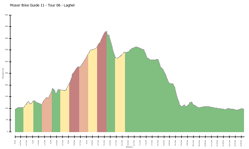
Diese Tour verzichtet auf schweißtreibende Gipfelfahrten, um die Blicke für die Landschaft entlang des Flusses Sarca frei zu haben. Bei der Sarcabrücke in Arco startet die Tour in Richtung Ceniga und Dro. Der Schotterweg führt an Olivenhainen vorbei bis zum Bocca del Cref, wo einige kurze Schiebepassagen oder Uphillprüfungen auf den Biker warten. Über Forstwege kreuzt man unterhalb des Bergmassivs des Monte Casale nach Pietramurata, dem Wendepunkt der Runde. Die höchsten Punkte der Tour hinter sich lassend, geht es durch Aulandschaft zurück nach Dro und bei Ceniga über die Brücke auf dem schon bekannten Weg.
http://www.gps-tour.info/en/tracks/detail.155.html
This tour dispensed sweaty summit trips to have open views of the landscape along the river Sarca. When Sarcabrücke in the Arco tour starts in direction Ceniga and Dro. The dirt road leads past olive groves to the Bocca del Cref, where some short shift passages or Uphillprüfungen wait for the bikers. About forest roads are crossed beneath the mountain massif of Monte Casale after Pietramurata, the turning point of the round. The highest points of the tour leaving behind, it goes through floodplain back to Dro and Ceniga over the bridge on the way already known.
http://www.gps-tour.info/en/tracks/detail.155.html
Mappa/Altimetria
Immagini